
26 apr 2019 | Blog, General News, GeoNetwork Article, Newsletter
Could you support us in our process of developing a modern Spatial Data Infrastructure (SDI)? The Lands Department in Hong Kong approached GeoCat with this question. As we are having a wide experience in this field, we set up a two-week tailored training, covering all...
17 apr 2018 | Blog, Bridge Article
GeoCat Bridge is an extension for ArcGIS Desktop and runs within ArcMap. This blogpost aims to explain what GeoCat Bridge does in more detail. In short; GeoCat Bridge enables you to publish the layers from a ArcMap map project (MXD) to GeoServer or MapServer as OGC...
18 jun 2017 | Blog, GeoNetwork Article
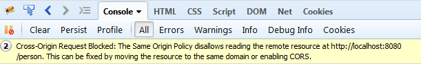
Browser based Spatial Data Infrastructure typically combines data from a variety of domains on a single web application (for example GeoNetwork). There are two typical errors that block optimal user experience in browser-SDI, which need some special attention. In both...
27 mrt 2015 | Blog, GeoNetwork Article
In a “conceptual friday” session of the “PILOD.nl” project we examined options and obstacles to expose Dutch Geospatial Data to the semantic Web. A number of technical and philosophical matters were discussed and tested: Will semantic...


Recent Comments