
9 Jul 2019 | Blog, General News
GeoCat was present at the OGC API hackathon in London. The event inspired our software developer Paul van Genuchten to step back and look at the latest developments. Do the standards meet the day-to-day needs of GIS professionals? And how can existing providers of...

26 Apr 2019 | Blog, General News, GeoNetwork Article, Newsletter
Could you support us in our process of developing a modern Spatial Data Infrastructure (SDI)? The Lands Department in Hong Kong approached GeoCat with this question. As we are having a wide experience in this field, we set up a two-week tailored training, covering all...
17 Apr 2018 | Blog, Bridge Article
GeoCat Bridge is an extension for ArcGIS Desktop and runs within ArcMap. This blogpost aims to explain what GeoCat Bridge does in more detail. In short; GeoCat Bridge enables you to publish the layers from a ArcMap map project (MXD) to GeoServer or MapServer as OGC...
18 Jun 2017 | Blog, GeoNetwork Article
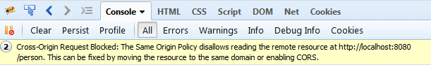
Browser based Spatial Data Infrastructure typically combines data from a variety of domains on a single web application (for example GeoNetwork). There are two typical errors that block optimal user experience in browser-SDI, which need some special attention. In both...
27 Mar 2015 | Blog, GeoNetwork Article
In a “conceptual friday” session of the “PILOD.nl” project we examined options and obstacles to expose Dutch Geospatial Data to the semantic Web. A number of technical and philosophical matters were discussed and tested: Will semantic...


Recent Comments